


Miner Voting District, Scott County, Missouri
About
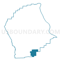
Outline

Summary
| Unique Area Identifier | 611370 |
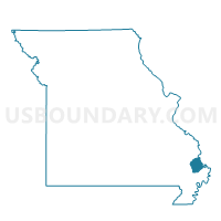
| Name | Miner Voting District |
| County | Scott County |
| State | Missouri |
| Area (square miles) | 9.09 |
| Land Area (square miles) | 9.07 |
| Water Area (square miles) | 0.02 |
| % of Land Area | 99.75 |
| % of Water Area | 0.25 |
| Latitude of the Internal Point | 36.89805240 |
| Longtitude of the Internal Point | -89.52086540 |
Maps

Graphs
Select a template below for downloading or customizing gragh for Miner Voting District, Scott County, Missouri


Neighbors
Neighoring Voting District (by Name) Neighboring Voting District on the Map
- Airport Voting District, Scott County, MO
- Bertrand Rural Voting District, Mississippi County, MO
- BIG PRAIRIE 3 Voting District, New Madrid County, MO
- Blodgett Voting District, Scott County, MO
- Broadway Voting District, Scott County, MO
- Diehlstadt Voting District, Scott County, MO
- Kingshighway Voting District, Scott County, MO
Top 10 Neighboring County Subdivision (by Population) Neighboring County Subdivision on the Map
- Richland township, Scott County, MO (16,833)
- Big Prairie township, New Madrid County, MO (3,419)
- Sandywoods township, Scott County, MO (2,353)
- Long Prairie township, Mississippi County, MO (1,348)
Top 10 Neighboring Place (by Population) Neighboring Place on the Map
Top 10 Neighboring Unified School District (by Population) Neighboring Unified School District on the Map
- Sikeston School District, MO (20,716)
- New Madrid County R-I School District, MO (9,385)
- Charleston R-I School District, MO (8,525)
- Scott County R-IV School District, MO (5,905)
Top 10 Neighboring State Legislative District Lower Chamber (by Population) Neighboring State Legislative District Lower Chamber on the Map
Top 10 Neighboring State Legislative District Upper Chamber (by Population) Neighboring State Legislative District Upper Chamber on the Map
Top 10 Neighboring 111th Congressional District (by Population) Neighboring 111th Congressional District on the Map
Top 10 Neighboring Census Tract (by Population) Neighboring Census Tract on the Map
- Census Tract 7804, Scott County, MO (5,335)
- Census Tract 9601, New Madrid County, MO (4,565)
- Census Tract 7806, Scott County, MO (4,306)
- Census Tract 9501, Mississippi County, MO (3,887)